
Post-oil spill observation trip at Bay Jimmy, LA
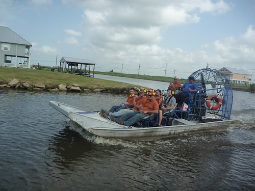
July 31st, 2010 by Cesar HaradaHi, Cesar Harada here, first post and first map using the techniques of Grassrootsmapping.org for LA Bucket Brigade – thanks guys for putting this wonderful DIY technology together. So! In the late morning 22nd of July 2010, Hunter Daniel and myself went to map out of Port Sulphur, on these funky boats :
With 2 boats we took this route (see google map) :
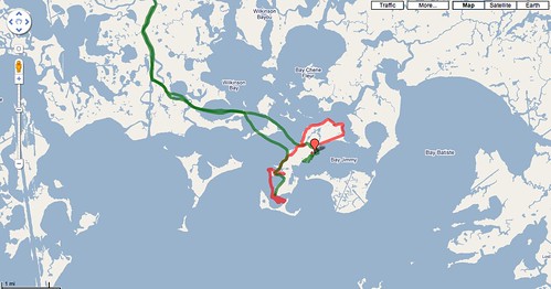
I traced this route with my mobile phone Google Nexus One and the fantabulous Open GPS tracker for Android – 4 stars rating!
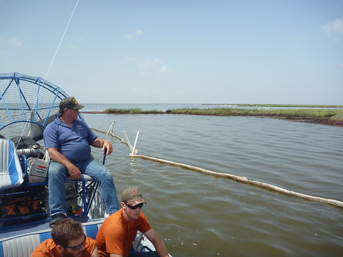
This is what we could see from the boat, kinda boring :
Soon after I launched a balloon and Hunter a kite out there, kinda exciting :
we captured nice pictures, here 6 details :
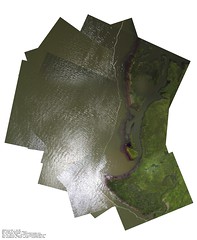

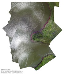
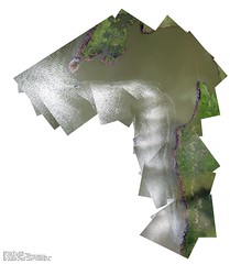
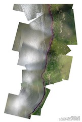
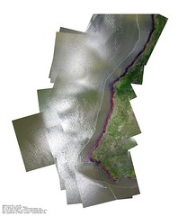
These 6 pictures were made using 270 stills… that was a 12 hours work on photoshop since hugin (an open-source photo mosaic software) didnt do the trick – yet :/ Still working on it to automate the process and spend more time sipping mango juice 🙂
In addition to what we had a bad GPS trace – my bad, I mean, it is good but I did’nt know where we started taking pictures on that route… Also the GPS time-stamp and the camera time-stamp did not match… So, here is the trick I found:
– find your point of interest on any map system, write down the coordinates of the top left hand corner of the tile you want to produce.
– go to http://pallit.lhi.is/bigice/bigpic.html , from here enter your Lat and Long (me : 29.468400, -89.911300), the zoom, number of tiles etc… hit “submit”. It will produce a huge map with a static URL. In my case the URL that produced the map (everything is in the URL PHP request) you see here :
http://pallit.lhi.is/bigice/supergooger.php?lat=29.468400&lon=-89.911300&zoom=18&x_tiles=40&y_tiles=40
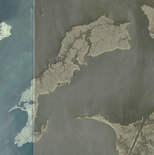
Ok, so now we have this huge empty map :
That’s another 6 hours work adjusting 700 pics layer by layer on photoshop ; hey, 270 images in 12 hours VS 700 images in 6 hours => see, it is much faster with a support map! We got that :
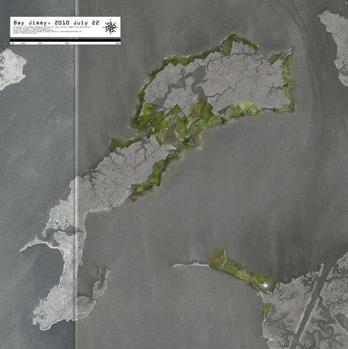
Don’t forget to put a scale and cardinal orientation + legal mentions.
So, under your eyes that’s a 17000 x 17000 pixel map, made of 970 pictures taken at 1000ft altitude, depicting about 5 linear km of damaged coastline. Combining the 6 details views and the general map we could observe that the south side was much more exposed to the spill (more dark brown brrrrr). Using this map we could also establish that on the exposed side, even the inland waterways are strongly affected by the spill : we can use these maps to quantify the surface affected by the oil spill, and the mass of crude attached to the surface coastline. Now even cooler, you can see these maps on google earth, download the KMZ file here (dont worry it is a tiny file – all the content is online). FLY !
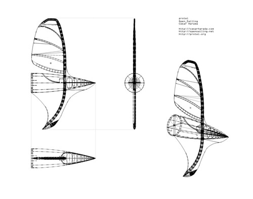
Apart from mapping this catastrophe – which is very useful for scientific study and for lawsuits against BP- why am I personally learning aerial photography? Well, because I am currently designing an oil collecting robot called “protei“.
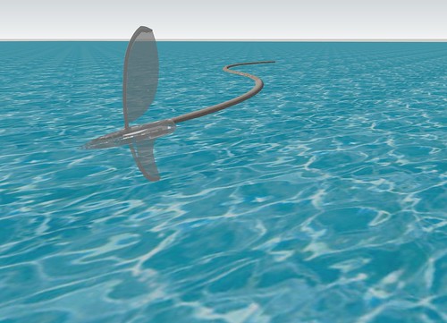
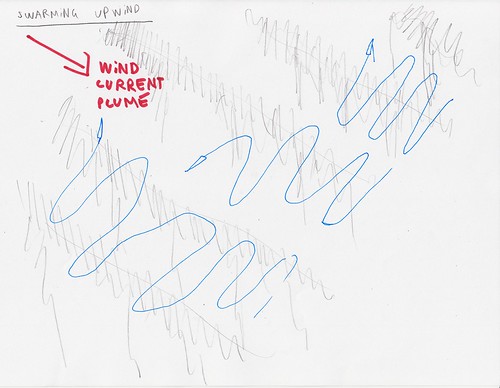
Protei is a sailing semi-autonomous robot with a long oil absorbing tail. Surface oil drifts downwind, so Protei sails upwind, taking and taking, intercepting oil sheens. Imagine many many of these cheap machines out there in the ocean collecting oil 🙂
After some research …
I built a steampunk test machine that is pretty promising with a flexible hull front-steering :

We are also testing at sea the behavior of a long tail, and same, going pretty well …
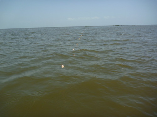
See these little balloons on the surface of the water? And this is when aerial photography comes handy : to evaluate the efficiency and behavior of Protei, seeing everything from above helps a lot, I can see the trajectory, the movement of the tail, the interaction with oil. Also having a highly visible “flying flag” in the sky is amazing to optimize safety and long range communication (flying antenna)… Exciting no? And the challenge is here, millions of liters of crude oil gushing in the Gulf of Mexico, in the Niger Delta, in Latin America, the middle east, in Asia… Protei_Oil_Spill has a busy future!
Of course, just like grassroots mapping, Protei is developed open-source and collaboratively, so I hope that sometimes soon, Protei will come back to land with a lot of amazing pictures for LA Bucket Brigade and its amazing oil spill map, GrassrootMapping, Cartagen and Open_Sailing! I received most electronic parts for the next prototype of Protei_Oil_Spill this morning (YAY!), I am building in New Orleans, so if you are around, or if you want to help the project remotely, do get in touch – cesar@protei.org – thanks!


November 2nd, 2010 at 5:25 am
have you seen autostitch
http://cvlab.epfl.ch/~brown/autostitch/autostitch.html
it seam to work on all sorts of odd images?
November 2nd, 2010 at 6:48 am
Yes, we’ve tried automatic stitching but it hasn’t resulted in any successful maps yet – most systems assume a fixed camera position (that is, you spin the camera, but don’t move it), rather than what we have, which is all over the place, all altitudes, etc.
That’s not to say it’s impossible, but I think we appreciate the more participatory hand-stitching anyways, and so far nobody’s demonstrated an automated system which is more effective. Please get in touch if you do!
November 4th, 2010 at 11:11 pm
I dont know if you guys have tried this, but it remarkable.
Sony’s Intelligent Sweep Panorama Mode
http://www.sony.co.uk/article/id/1237476029876
it works really well.
There must be some on-the-fly stitching
http://www.co.palm-beach.fl.us/publicsafety/emergencymanagement/floodawareness/expo/_images/lidar1.gif
Pretty sure, military have this 🙂
But just like Jeff said, if you have a really good [preferably open-source one] Shout !
Thanks !
January 24th, 2011 at 9:18 am
[…] Download these full resolution maps to your computer as .zip file (27mb). If you want to learn how to make one of these map, check this post. […]
November 6th, 2012 at 7:27 am
[…] York Harbor. [DIY aerial photography of the Louisiana coast line, post oil spill; courtesy of grassroots mapping] The educational project as opposed to the production and consumption of the commoditized […]
January 9th, 2013 at 5:48 am
[…] se dirige alors vers la Nouvelle-Orléans, où il travaille avec la Louisiana Bucket Brigade afin de cartographier la nappe de pétrole du Golfe du Mexique. Et au même moment, il commence à […]