Grassroots Mapping is a series of participatory mapping projects involving communities in cartographic dispute. Seeking to invert the traditional power structure of cartography, the grassroots mappers used helium balloons and kites to loft their own “community satellites” made with inexpensive digital cameras.

This site has been merged into Public Lab

At Public Lab, we've grown the Grassroots Mapping community into a broader effort to enable communities to understand and respond to environmental threats with DIY techniques.

Read more and join us »

Lima, Peru: Kite Making/Ballon Mapping Workshop, U. of San Marcos

February 2nd, 2012 by anita

We held a Ballon Mapping and Kite Making Workshop on the Campus of San Marcos on Jan. 28, 2012 with a group of about 10 people from: Open Street Map Peru, Saberes Nomadas, and San Marcos Univ. (physics, geography, sociology, and geographic engineering depts.)

read more

Neutrality and cartography in Cantagallo

February 17th, 2010 by Jeffrey Warren

Another day, another new grassroots map! After working with residents of Cantagallo at the beginning of February to produce the first map of their community with Daniel Miracle of Escuelab, we met with members of another of the 3 groups of Shipibo living in the same zone in the center of Lima. Upon seeing the maps we’d made, they were excited to make one also.

Sara Gomez of CEDRO, who introduced us to Sr. Ricardo, the president of one of the multiple political groups in Cantagallo, pointed out that if we make a map, we should do the best to serve all parties who live in Cantagallo – meaning that, among other things, we should create a single map of the entire settlement, collaborating with as many groups as we can, and distribute it as widely as possible. The situation was complex – the political groups don’t break down along clear geographic lines, but they are engaged in geographic dispute, and are submitting separate bids for state recognition. I’m still struggling with how to aid these groups in their bid for land title without getting pulled into a local political conflict — if that’s even possible. We cannot say, for example, that this mapmaking is a neutral act – but we can try to create tools which support equal access to geodata, and which are hard to use in exclusionary ways.

It remains to be seen how this plays out, but at the very least, we were able to work with a Señor Ricardo – president of one of the other Shipibo groups – to make a more complete map. Politics aside, once you get outside and start flying balloons, everyone becomes an excited kid, at least for a while.

My hope is that these maps will support all parties’ claims to title in their negotiations with the Municipality more than they create or further aggravate disputes between the various groups in Cantagallo. I’ll be staying in close contact with my friends there to see what happens.

Completed, printed map of Juan Pablo II!

January 30th, 2010 by Jeffrey Warren

Late Wednesday I finally finished the first draft rectification of the kite/balloon images from Juan Pablo II and also of Cantagallo; I took a cab out to Surco to where they have plotters and ran off a couple big maps for each community. On Thursday, Carla, Nancy, and the CEDRO teachers stayed out the whole day in Villa el Salvador because there was a parent teacher meeting at 6pm. In the meantime we got out the big map and all the kids found their homes (just like in Google Maps, right?) and outlined them on trace paper.

The best part of the day was meeting the parents and showing them all the great work the kids had done on both the history “project” and the “future” project. The model of the community in 7 years (as mentioned in a previous post) was especially exciting. See all pictures of the history/future projects on Flickr.

And finally, we presented the completed map of Juan Pablo II to the parents as well. Since the kids had outlined homes and such, we were able to show the president of the community (several of the leaders came) a completed map with annotations. He seemed pretty excited and we’re meeting up with him on Tuesday to talk more about it, and possibly stitch the map we’ve made onto an overall community plan they already have. This should help them fill in detail like homes and streets.

The meeting was at night, so we had a free afternoon, giving Cesar, Jesus, Jian, and a bunch of other kids the chance to build a really huge kite from bamboo and trash bags.

The kites didn’t all fly (Cesar’s did!) but we learned a bit about what makes a good kite. Next time we’ll try for a really huge one that is still stable.

History & Future of Juan Pablo II

January 27th, 2010 by Jeffrey Warren

The CEDRO teachers and I were inspired by Jay Silver’s work with Awareness Mapping (watch his presentation here) and so we’ve been doing some paper mapping exercises, though focusing more on history and buildings and such. The ‘history of the community’ project (view on Flickr) went so well that we assigned a ‘future of the community’ assignment and asked kids to bring in maps or drawings of the community in 5-10 years. They came back with some great stuff (see the project on Flickr), and two students went nuts and made a whole scale model of the neighborhood (7 years from now) in 3D!

Notice the great attention to detail in multiple story homes. There’s a pharmacy, hair salon, etc. I’ll be uploading more photos of this assignment soon, including a panorama of the model town!

Grassroots Mapping with the Shipibo in the center of Lima

January 23rd, 2010 by Jeffrey Warren

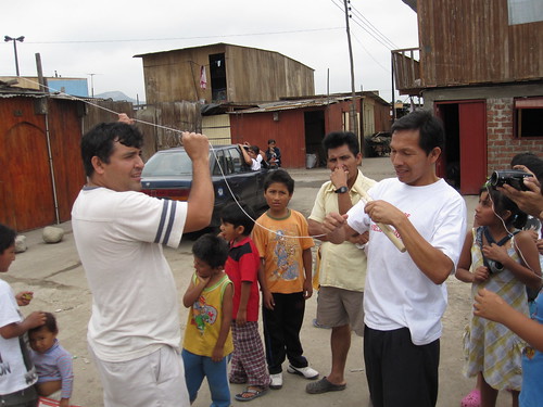
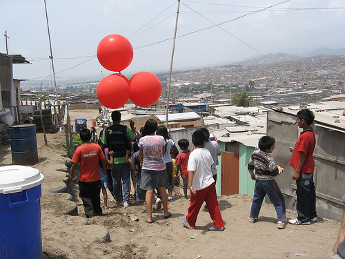
Yesterday turned out to be a fantastic day – Daniel Miracle and others from Escuelab took me out to visit a community called Cantagallo which they’ve been working with for some weeks. Daniel sets up TV transmitters and creates local TV stations with a range of ~500 meters for only about $300.

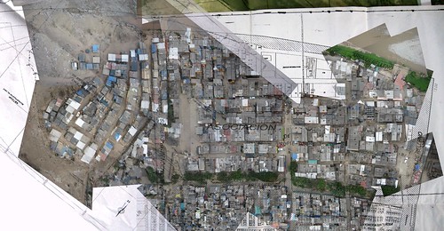
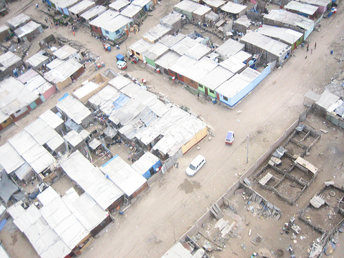
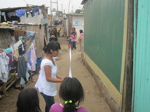
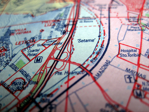
The Cantagallo community is a group of Shipibo, a group native to the Amazon region of Peru, near Pucallpa. About 100 families have moved here to the bank of the river Rimac here in Peru, on top of a landfill, starting about 9 years ago. They’re currently in negotiations to gain a title to the land they’ve been living on, which the Escuelab folks believe belongs to the Municipality of Lima. They invited me out to come make maps with them in the hopes that the resulting data can support their territorial claim. Seeing a community so tightly knit, isolated on top of a small hill, in the middle of a metropolis of 11 million people, was pretty stunning.

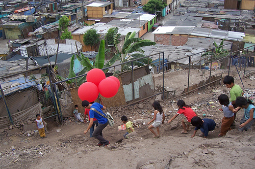
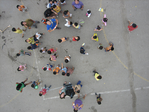
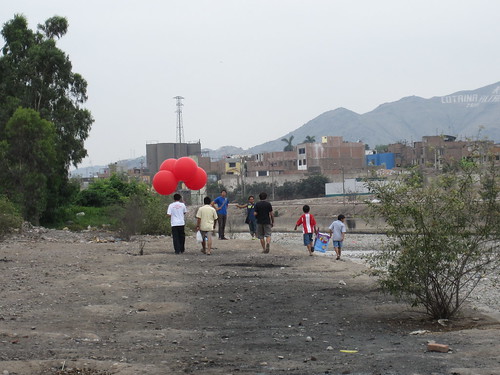
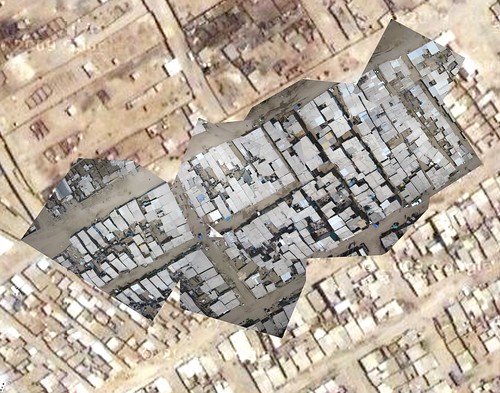
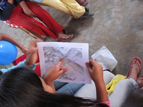
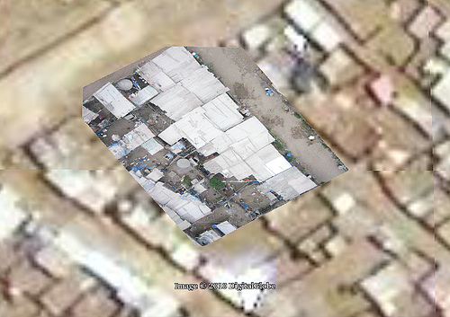
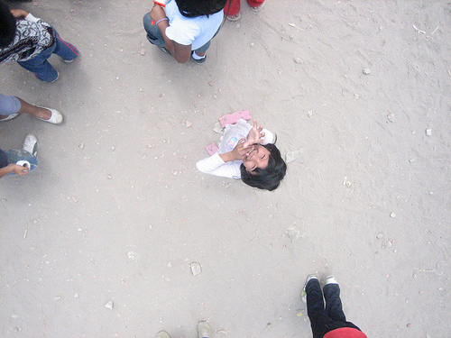
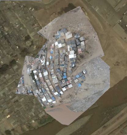
The Shipibo kids were very sweet and with the exception of one kid who threw a rock at the balloons and popped one (he was sorry and pretty sad afterwards when I explained we’d used all our helium and couldn’t send the camera up anymore), very helpful with the kites and the balloons. There was some wind but we couldn’t get the kites to pull consistently, so we inflated 4 balloons and that worked fabulously! We managed to take clear, detailed photos of the entire site, and I rectified them last night in just about an hour. I’m doing a rectifying workshop at Escuelab today and have also promised to show Nancy and Carla from Manzanita “A” how to do this. See above the resulting map overlaid on Google Earth imagery, which looks to be about 3-4 years old. And of course nothing is shown on a standard paper street map of Lima:

I thought it was really interesting that the community still actively uses the Shipibo language, but also that there’s a debate among parents there as to whether it should be taught; some think that Spanish alone would be more useful for their kids. The state-run school there is bilingual. Other aspects of the Cantagallo community also show their dual desires to hold on to their cultural roots while still being successful in modern Lima. According to Daniel, even their choice of location – next to the Rimac river – was because they were accustomed to living next to a river and fishing.

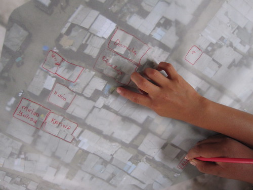
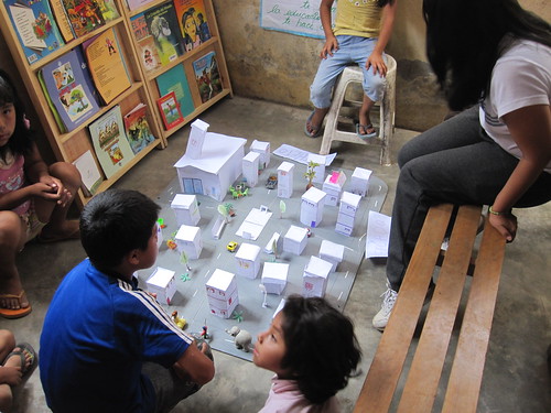
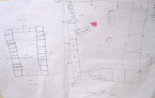
We also managed to take a picture of a map the Shipibo of Cantagallo are using as part of their title negotiations – and hope to fill it out with streets, homes, etc. More on this soon.

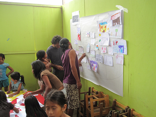
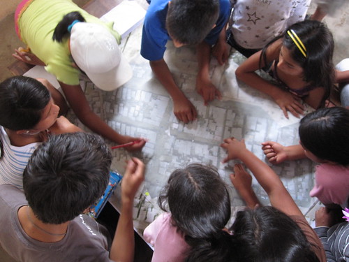
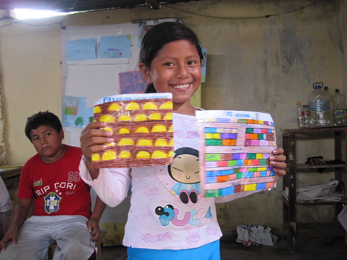
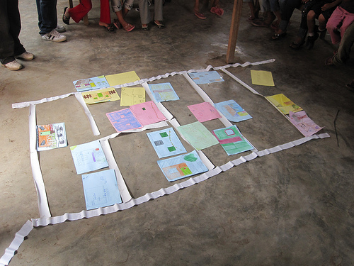
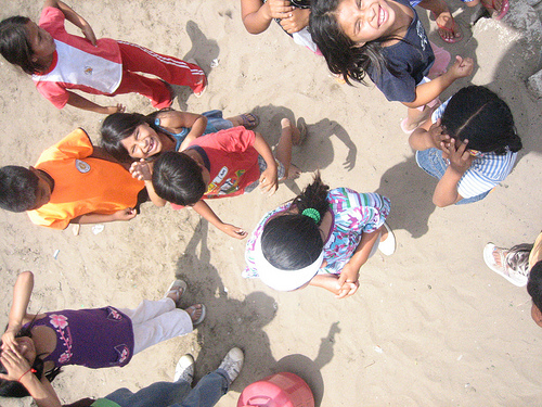
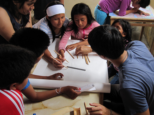
And as we’ve been having a lot of success with paper mapping with kids in Juan Pablo II, we made a big collage map with the Cantagallo kids as well. We had a lot of help from Layner Morih, a young Shipibo guy who has a great rapport with the kids – he encourages them to speak in both Spanish and Shipibo. You can see him in a purple shirt helping assemble the drawn map.

Lots more pictures on Flickr

Continued kite-flying and paper mapping

January 21st, 2010 by Jeffrey Warren

Quick update – we’re continuing to fly kites and take pictures but we’re waiting for our ‘perfect day’ of kite flying… so far we’ve had a rough time with the wind and haven’t yet gotten the cameras high enough to take an overall picture. But we’re trying again Saturday in Juan Pablo II. Above, we asked the kids to draw pictures of their houses, and as a group activity, we organized them into a map to get a better idea of how the community is shaped.

Tomorrow I’ve been invited by some activists and artists I met at Escuelab to come out to a community called Cantagallo in the center of Lima, where an entire community from the Amazon region of Peru has relocated as a block to the bank of the river Rimac. They’re doing a project there and are really excited about making a map – and the community is looking to establish legal tenure. Perfect! I’ll post some pictures on Saturday.

Below, Sandy from CEDRO examines an aerial photograph we took last Thursday. Since the Google imagery, the residents of Juan Pablo II have added an entirely new street, and completely reorganized their homes… the Google map is badly outdated.

Initial Map Warper test with kite imagery

January 16th, 2010 by Jeffrey Warren

We’re working to process and rectify all the imagery we captured on Thursday, but here’s an initial attempt at rectifying an image. I must admit I was initially discouraged that the Google map seemed pretty decent (it’s supplied by DigitalGlobe) but now that I’m trying to actually rectify images against it, it’s really almost unusable!

I can’t see any useful detail, and almost all of the houses have moved or changed… about one in a hundred roofs match up, making it very difficult to rectify. I think we need one really good very high altitude shot to fix our overall layout, then we can rectify the lower altitude, higher detail imagery. We’ll try Tuesday afternoon.

Mapping with balloons, kites, and kids – first flights with Juan Pablo II in Lima

January 15th, 2010 by Jeffrey Warren

Yesterday Seth Hunter and I had our big flight with teachers from CEDRO and Manzanita “A” and the kids from invasion Juan Pablo II, and everything went extremely well. We started by reviewing the Google Maps imagery of the area (see previous post) and discussing their new homework project of writing about the history of the community, when their family arrived and from where, etc. (see the full homework on the Grassroots Mapping wiki). This was put together with the team from CEDRO — Ernesto, Sandy, Sara, and others, whose fantastic work and thorough understanding of the kids we’re working with has made this all possible. I’ve been very impressed with their personal commitment to the community – they know all the kids and their families, and have a very good rapport with the residents of Juan Pablo II.

After a short discussion of the camera rig and some helium safety tips/rules, we set out to launch our first balloon – or rather 5 balloons, which is what it took to launch our camera.

However, there was quite a bit of wind, and things got a bit turbulent. The rig kept getting pushed down by gusts, and with all the DIY electrical wiring around, we told the kids to let go of the string for a bit. Ultimately, though, we had a big crowd, and the kids helped with everything from filling balloons to tying the rigging — and most importantly, they had a ton of fun.

We were unsure about the pictures we’d get, and indeed we didn’t really get high enough with the balloons (see above) so later, with a smaller group of kids we tried flying kites, which worked fantastically – we got the camera up quite high and captured some really good imagery which we hope to rectify later today or tomorrow. To produce a complete map, we expect to repeat kite/balloon flights over the next week or so.

All in all, the day went terrifically well; many thanks to the aforementioned members of CEDRO as well as Carla del Carpio and Nancy, who were also there to participate.

The complete set of photos of the event are being uploaded to Flickr under the tag “grassrootsmapping”.

Juan Pablo II on Google Maps

January 15th, 2010 by Jeffrey Warren

Here’s Juan Pablo II (as far as I can tell) on Google Maps. (Link here)

It doesn’t look so bad in fact… we’d expected older imagery. But the detail is not quite good enough to make out which homes are which, and there are no labels or anything, so it’s quite hard to figure out where you are. We’ll see how these sync up with the higher resolution balloon imagery we capture… hopefully tomorrow!

First day of mapping in invasion Juan Pablo II, in Lima, Peru

January 13th, 2010 by Jeffrey Warren

Yesterday we had our first mapping session with the kids from Juan Pablo II, the invasion we’re working in. Carla took Seth and I up to Villa el Salvador, and after walking around a bit to get oriented, we met up with Ernesto, Sandy, Sara, Nancy, and Johann, who are doing the project with us. We spent some time gathering kids up (quite a few had to work today, so we had a smaller class of about 8), and then got right down to drawing maps. The kids enjoyed debating where they lived and how far away, and we ended up with a nice map that was not so literal, but got them oriented a bit and in the mapmaking mind-set.

Then the others had a great idea, and we all set to making some long tape-measures from some large sheets of 1 inch graph paper. This took a while but the kids were very efficient and we broke into groups of 2-3 to measure some of the ‘manzanas’ or blocks that the homes are divided into.

Each block has about 10-15 homes, and we measured them to the inch! It’ll be fun to see how these hand-measured maps match up to the aerial pictures we hope to take.

The kids got all tired out and to tell the truth, so did the adults. We finished up with the kids and then had a wrap-up meeting where we talked about scheduling the next few classes, discussed what worked and what didn’t (the kids seemed to lose interest in measuring things after about 20 mins or so… especially as it got towards lunchtime) and planned out some more activities. We hope to do a balloon launch on Thursday, but we’ll see how the weather looks.

Anyways thanks to everyone who participated for a fantastic and gratifyingly exhausting first day! Seth and I are posting more photos on Flickr.

Here’s a great picture of the wall at the edge of the invasion which separates the community from the ocean: