
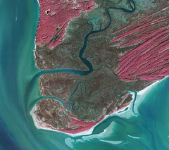
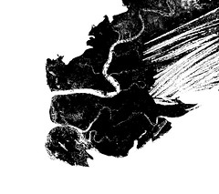
Quantify wetland from aerial UV photo
February 24th, 2011 by Cesar Harada>>Question : How can you extract the % of wetland from an UV aerial picture using photoshop?
Video tutorial by Cesar Harada and Adam Griffith:
_ Instructions :
1. isolate the part that you are interested in using the menu/ image/ adjustment/ replace color. There you want to have a quite fuzzy selection and darken the desired part.
2. after isolating the part you are interested in -black area- apply menu/ image/ adjustment/ threshold
3. use magic wand /untick “contiguous” pixel to select all the black pixels available. Open menu/ window/ histogram/ expanded view. Here you will see how many black pixels are selected. Now you know how many black pixels there is on this image – corresponding the area of wetland from the original UV picture. You can convert the number of pixels into a % (proportions of wetland) or in surface area for quantifying. It is possible to optimize this workflow by creating a script or recording the chain of actions.
Same thread on Public Laboratory


