
Picavet PET rig
February 5th, 2012 by mathew
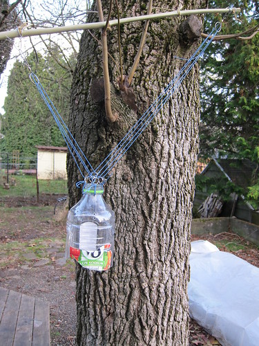
A Picavet rig is a very common type of KAP/BAP rig, I've added it to the juice bottle in a fairly simple way, using 1/2" key rings.
At Public Lab, we've grown the Grassroots Mapping community into a broader effort to enable communities to understand and respond to environmental threats with DIY techniques.
A Picavet rig is a very common type of KAP/BAP rig, I've added it to the juice bottle in a fairly simple way, using 1/2" key rings.

This is Aurora Tang's method of sealing up her balloons. I think its the best I've seen. It was developed during a project to document Robert Smithson's Spiral Jetty with the Getty Institute. She has used it extensively for landscape photography.


We held a Ballon Mapping and Kite Making Workshop on the Campus of San Marcos on Jan. 28, 2012 with a group of about 10 people from: Open Street Map Peru, Saberes Nomadas, and San Marcos Univ. (physics, geography, sociology, and geographic engineering depts.)


I've made an instructional video on efficient image sorting with Preview and Finder, for quickly winnowing down big groups of images to small sets, ready for MapKnitter:

This is for use with the PET Bottle Rig
Instead of using a balled up piece of tape, a pebble, or some other thing to hold down my camera's shutter, I've gone to using a knot. This makes it easy to hold in place, and makes setting it easier. I prefer a rubber band, but tape also holds it down. tape may be more useful for bulging, non rectangular cameras.

This post has been syndicated from EPSG4253.wordpress.com
Today, we had a balloon mapping experiment. For a very brief airtime, we got some really impressive images.


cross-posted from PBS's IdeaLab. Making maps from balloon and kite flights in the dynamic coastal wetlands areas.
cross-posted from PBS's IdeaLab. Making maps from balloon and kite flights in the dynamic coastal wetlands areas.

This is a snapshot of some multispectral imaging that I have been working on with Pat Coyle at the organic agriculture park in Sunol, California. http://www.sagecenter.org/sunol-agpark/
near infrared tool:
http://publiclaboratory.org/tool/near-infrared-camera
Jeff Warren's NRG tutorial: http://youtu.be/Sfic43qRHqk
Warren on NDVI: http://youtu.be/-nNnWEHNO_w
Are you embroiled in an cartographic dispute? Do you disagree with the official version of your geography? Contact us through the public mailing list.
Grassroots Mapping is part of the Public Laboratory for Open Technology and Science, founded by a group of activists, educators, technologists, and community organizers interested in new ways to promote action, intervention, and awareness through a participatory research model.
We're now trying to learn from our balloon mapping experiences to develop new DIY tools with a variety of local communities. This is an open community and you are welcome to join, and encouraged to contribute!

Purchase the Grassroots Mapping Forum, our new community research journal/archive/zine/map, where we hope to share ideas, techniques, and stories from the Grassroots Mapping community. It is printed on a single 22.75x35" newsprint sheet, folded down to just over letter size, and includes a full color reproduction of a grassroots map along with essays, illustrated guides, and interviews on the reverse.
You can find out more, and purchase the first issue here for $17 shipped.

We're helping citizens to use balloons, kites, and other simple and inexpensive tools to produce their own aerial imagery of the spill… documentation that will be essential for environmental and legal use in coming yeas.We believe in complete open access to spill imagery and are releasing all imagery into the public domain.
You can see all of our data here: http://publiclab.org/archive/.
Browse some of our best imagery on Flickr.

Techniques and tools for people who want to make maps, on the Public Laboratory wiki. Includes readings and case studies on grassroots mapping projects.

Instructions on how to use cameras on weather balloons to create high-resolution maps.

Want to start mapping? See the Balloon Mapping Materials List to get started.


