
Grassroots Mapping with the Shipibo in the center of Lima
January 23rd, 2010 by Jeffrey Warren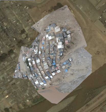
Yesterday turned out to be a fantastic day – Daniel Miracle and others from Escuelab took me out to visit a community called Cantagallo which they’ve been working with for some weeks. Daniel sets up TV transmitters and creates local TV stations with a range of ~500 meters for only about $300.
The Cantagallo community is a group of Shipibo, a group native to the Amazon region of Peru, near Pucallpa. About 100 families have moved here to the bank of the river Rimac here in Peru, on top of a landfill, starting about 9 years ago. They’re currently in negotiations to gain a title to the land they’ve been living on, which the Escuelab folks believe belongs to the Municipality of Lima. They invited me out to come make maps with them in the hopes that the resulting data can support their territorial claim. Seeing a community so tightly knit, isolated on top of a small hill, in the middle of a metropolis of 11 million people, was pretty stunning.
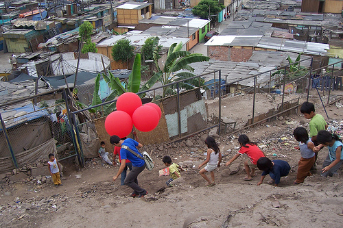
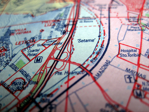
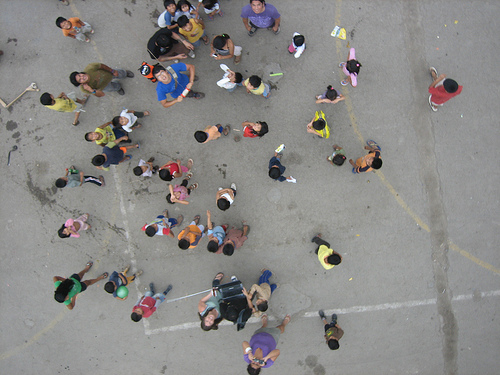
The Shipibo kids were very sweet and with the exception of one kid who threw a rock at the balloons and popped one (he was sorry and pretty sad afterwards when I explained we’d used all our helium and couldn’t send the camera up anymore), very helpful with the kites and the balloons. There was some wind but we couldn’t get the kites to pull consistently, so we inflated 4 balloons and that worked fabulously! We managed to take clear, detailed photos of the entire site, and I rectified them last night in just about an hour. I’m doing a rectifying workshop at Escuelab today and have also promised to show Nancy and Carla from Manzanita “A” how to do this. See above the resulting map overlaid on Google Earth imagery, which looks to be about 3-4 years old. And of course nothing is shown on a standard paper street map of Lima:
I thought it was really interesting that the community still actively uses the Shipibo language, but also that there’s a debate among parents there as to whether it should be taught; some think that Spanish alone would be more useful for their kids. The state-run school there is bilingual. Other aspects of the Cantagallo community also show their dual desires to hold on to their cultural roots while still being successful in modern Lima. According to Daniel, even their choice of location – next to the Rimac river – was because they were accustomed to living next to a river and fishing.
We also managed to take a picture of a map the Shipibo of Cantagallo are using as part of their title negotiations – and hope to fill it out with streets, homes, etc. More on this soon.
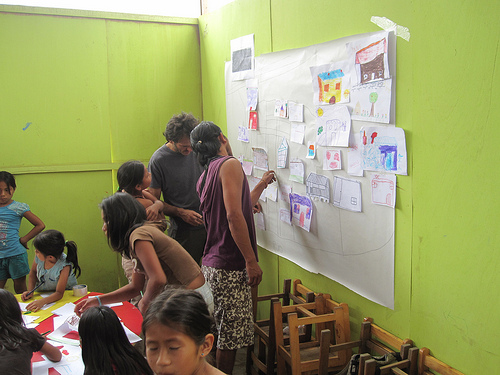
And as we’ve been having a lot of success with paper mapping with kids in Juan Pablo II, we made a big collage map with the Cantagallo kids as well. We had a lot of help from Layner Morih, a young Shipibo guy who has a great rapport with the kids – he encourages them to speak in both Spanish and Shipibo. You can see him in a purple shirt helping assemble the drawn map.
Lots more pictures on Flickr
Tags: lima


January 23rd, 2010 at 1:40 pm
[…] Grassroots Mapping with the Shipibo in the center of Lima […]
January 23rd, 2010 at 5:19 pm
Wow this is fantastic! I’m so happy to see the pictures and this looks like one of the best results you have had so far. This morning I presented your project to 100 high school kids at Urban Ecology Institute in Boston, where Kim works.
Seth
January 23rd, 2010 at 6:00 pm
[…] which supports communities in cartographic dispute by creating low-cost mapping tools.” Grassroots Mapping with the Shipibo in the center of Lima (Thanks, Jeffrey!) […]
January 24th, 2010 at 10:20 am
Hey seth – wish you were there, it was a lot of fun. I’m trying to get a final map together to print at poster-size. I also have a lot more photos I’ll keep posting in the next few days.
January 25th, 2010 at 2:34 am
[…] This post was mentioned on Twitter by Martijn van Exel, Matt Gedigian and TheEyeOfTim, Eclectica. Eclectica said: One more link before I go—mapping with aerial photography in Peru, using helium balloons: http://eclectica.co.uk/00239 […]
January 25th, 2010 at 5:49 am
Social comments and analytics for this post…
This post was mentioned on Twitter by TheEyeOfTim: Grassroots Mapping in Lima (via @BoingBoing) http://tinyurl.com/yf9kpm2…
January 25th, 2010 at 8:27 am
Hi there Jeffrey- Interesting project you’ve got here. Could you explain what you see as the benefits to using these techniques? It seems that the technology you’re using (camera, helium balloon, computer, software) isn’t really more accessible to impoverished people than conventional tools. Not trying to attack you at all. I’m just curious.
January 25th, 2010 at 9:34 am
Hi, Mike – good question! Well, conventional tools typically involve either GPS equipment, which at the accuracy needed costs over $150/unit (though loaned equipment can be used to do some pretty fantastic work: mapkibera.org) for several units, or buying satellite imagery, which I’m not even sure exists at good enough resolution and recency to be of use, not to mention it’s hard to imagine going to an internet cafe and paying for it online with a credit card if you live in Cantagallos.
So on the one hand, I’m just trying to bring the price down, and at the same time capture much *better* imagery, both on the basis of resolution and recency. The whole kite rig can be put together for only $50, and balloons are not much more, at about $150 (remember with GPS you’d probably have to buy a few of them, and they’re illegal in some countries).
I’d also say that the definition of the user base is important. I’m not just wandering into some settlement and launching a balloon – I’m working with dedicated groups of educators and aid workers who have worked with these communities for an extended period of time – years, in some cases. It’s just as important that Carla, Nancy, and Ysabel of Manzanita “A”, Daniel Miracle of Escuelab, and Ernesto, Sandy, and Sara of CEDRO become familiar with these techniques, since they have the trust of the residents of their respective target communities. And traditional GIS practices ask a bit much technologically – the way we’re doing it, you don’t even need to download an application – you can generate the map at an internet cafe using Firefox, if you like.
Of course I’m also trying to push the envelope here a bit, and to explore what works and what doesn’t, but it seems like a lot of the web-based neogeography toos have a lot to offer at a low barrier-to-entry compared to the GIS toolchain. So that’s an area of interest/research to me. (Full disclosure; I created Cartagen, which tries to completely upend some of the tile-based systems used by even the most cutting edge neogeographers, so obviously I have weird ideas about how maps should be made, LOL)
Finally, though, I’d say that beyond being cheaper and better (resolution, recency), the most important part of this balloon/kite process to me is that it does more to include residents of these kinds of settlements in documenting and *defining* their geography. To me, GPS is a great tool, but it’s kind of a black box as far as users are concerned — hell, I don’t even really really know how they work. Simply taking pictures of your home from above (pictures which YOU OWN, no less) makes immediate, tangible sense. You can even see yourself in every picture, holding the string! Which is to say that it’s a lot more tangible than a satellite. So there’s this other, more psychological, epistemological angle which is important.
Sorry to blabber on — I hope that makes some sense? Please don’t hesitate to criticize – I’m still refining these ideas so I’d love to hear your thoughts.
January 25th, 2010 at 3:14 pm
Thanks for the clarification Jeffrey,
I’m glad to see that your head’s in the right place as far as sustainable solutions. So many people these days do *humanitarian* projects that ultimately serve very little besides the originator’s ego. It will be interesting to see where this goes.
From my perspective it seems that it would be good to develop the home-made hot air balloon in kit form (financial limitations of helium) then package with instructions and supply local individuals with these kits so that they could serve specific communities like the Shipibo. If you got something like that up and running you could probably get a very strong donor response from members on photo.net for compact cameras that would serve your purpose. Sounds like fun- and definitely useful in certain situations.
Heck, you might consider hitting up goprocamera.com for camera sponsorship. Would be an intriguing application for their product. They’re light, shoot video and stills, and are cheap enough that they could potentially float you some units without breaking the bank.
Anyway- keep truckin and good luck.
Mike Bergen
NGO AidJoy
March 18th, 2010 at 2:05 pm
Nice project. If you need any help from the Peruvian autorouting map project, just ask.
http://perut.org/
November 7th, 2012 at 11:49 am
Thanks for another fantastic post. Where else may just anybody get that type of information in such an ideal approach of writing? I’ve a presentation next week, and I’m at the look for such info.
November 16th, 2012 at 5:22 am
I like it whenever people get together and share views. Great blog, keep it up!