
Wetlands loss imagery from Bayou St. Denis, Louisiana
September 21st, 2011 by Jeffrey Warren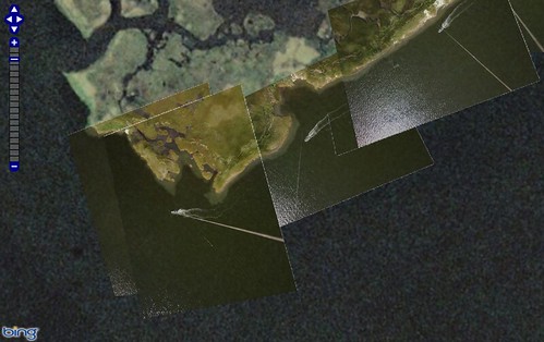
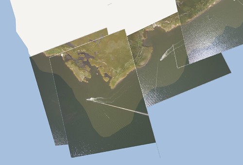
I’ve heard Shannon Dosemagen cite “a football field of wetlands loss every 30 minutes” along the Louisiana gulf coast, due to lower freshwater inflow/silt deposition, contamination, wake, and other issues. I was working on a map of balloon images of Bayou St. Denis recently and compared our imagery to that of Bing, which is a few years old. I believe these are pretty well lined up, based on the stream intersections, and you can clearly see the amount of land missing in the more recent images.
http://publiclaboratory.org/notes/warren/9-21-2011/wetlands-erosion-bayou-st-denis-louisiana
http://mapknitter.org/tms/bayou-st–denis/openlayers.html
I wonder how old the Bing imagery is. Google has stuff from a few weeks after the oil spill. Though it’s difficult to align these datasets given that the land itself is changing shape, the high resolution of the images that grassroots mappers captured makes it an interesting way to quantify wetlands loss. Hopefully our ongoing collaboration with Louisiana Universities Marine Consortium (LUMCON) will yield even more data for this area.
Compared to the Google Maps vector coastlines, there’s been even more loss; presumably these aren’t updated every time new satellite data is available:


December 4th, 2011 at 4:21 pm
hey, i’d like for GRN to be doing this on our field excursions. please let me know who is still in new orleans doing this.
USGS has a few relevant publications if you want to know the causes of wetlands loss in a particular area:
http://pubs.usgs.gov/of/2000/of00-418/ofr00-418.pdf
http://pubs.usgs.gov/sim/3164/
and i think we’ve exported some of these pubs to .kmz, if you are interested
for a healthy Gulf,
scott eustis
coastal wetland specialist